Walking Trails
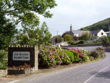
The Kilbrittain walking trails all start at the park in Kilbrittain, an historic village 15km west of Kinsale on the Wild Atlantic Way in West Cork.
-
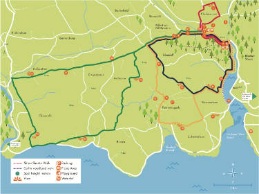
Castle Walk
- Grade: Moderate
- Length: 4.3km
- Type: Loop
- Ascent: 85m
Along quiet country roads. Through Village Park to Castle gates and return.
-
Estuary Walk
- Grade: Moderate
- Length: 7km
- Type: Loop
- Ascent: 95m
Quiet country roads, sea views, woodland.
-
Rathclaren Walk
- Grade: Moderate
- Length: 9km
- Type: Loop
- Ascent: 95m
Country roads, old church and graveyard woodland and estuary views.
-
Kiln Walk
- Grade: Moderate
- Length: 14.5km
- Type: Loop
- Ascent: 95m
Country roads, church ruins, estuary views.
Map of Kilbrittain Walking Trails

- Village Park
- Fin Whale
- Playground
- Clashavanna view
- Killbrittain Castle
- Waterfall
- Dower House
- Dorothy Stopford Price
- St. Patricks Church
- The Republican Plot
- Creamery
- The Lookout
- Garranefeen view
- Kilbrittain Creek
- Trinity Well
- Don Byrne’s Grave
- Rathclaren Church
- Lisheenaleen view
- Sand Dunes view
- Cloundereen Church
- Con Murphy Monument
- Ballycatten view
- Kiln view
- Cloon Calla view
- Ardacrow view
- Causeway
- Garda Station
- Coolmain Castle
- 1916 Memorial Garden
Points of Interest


-
About Kilbrittain
Kilbrittain is situated midway between Kinsale & Clonakilty. This scenic part of West Cork has many sandy beaches and castles to offer the visitor, a mecca for walkers, cyclists, water sport enthusiasts, bird watchers, fishermen and horse riders.
-
Fin Whale
On 15 Jan 2009 an 18 metre fin whale stranded and subsequently died on Burren Beach. The people of Kilbrittain organised to save its skeleton which is now displayed in the village. The whale was featured in a Channel 4 documentary “Inside Nature’s Giants” which showed autopsies of large mammals. It is still viewable on the Channel 4 website or on YouTube.
-
Playground
There is a lovely picnic area and a great children’s playground with separate areas for Under 6, 6-14 and adult exercise equipment. There is also a sensory garden right beside the playground.
-
Clashavanna view
Overlooking the ruins of Clashavanna church (original site of Kilbrittain Village), Kilbrittain Castle and The Blanket Wood.
-
Kilbrittain Castle
Kilbrittain Castle is the oldest inhabited castle in Ireland. The Castle is said to date from 1035 built by Brodchon, grandson of Brian Boru. It was known to have been in the hands of the Norman family of de Courcey. Kilbrittain Castle was the principal seat of MacCarthy Reagh family, Riabhach (Riabhach meaning dark skinned). Following the battle of Kinsale it came into the ownership of The Hollow Blade Steel Company and subsequently by the Stawell family who extensively restored and enlarged it. It was then purchased and restored by inventor Russell Winn in 1969. Winn invented a remote control robot vehicle for bomb disposal. Kilbrittain Castle It is now in private ownership (Cahill O’Brien Family). The Book of Lismore was compiled in the 15th Century to commemorate the marriage of the Gaelic lord Finghin Mac Cárthaigh Riabhach, of Kilbrittain Castle, to Caitilín, daughter of the Seventh Earl of Desmond.
-
Waterfall
The starting point is at the Village Park (1) where you descend to the river. Here you cross the footbridge and enjoy the wooded riverbank until the walk finally draws you upwards over the ridge and back to Kilbrittain village via the Community Centre Field.
-
The Dower House
The Dower House was built in 1683, as a defence/look out tower as well as the tax collection point for visitors to the Castle.
-
Dorothy Stopford Price
Dorothy Stopford Price (8 /9/1890 – 30/1/1954) was an Irish physician who contributed to the elimination of childhood tuberculosis in Ireland by introducing the BCG vaccine. After she qualified as a doctor, Dorothy’s first job was as a dispensary doctor in Kilbrittain, where she also engaged in the Irish War of Independence, tending to injured members of the IRA.
-
St. Patricks Church
Kilbrittain Parish Church was built in 1790 by Fr. Patrick Geran OSF(1760-1814). It was extended sometime in the 1840’s. The Church was dedicated to St. Patrick on the 10th of June 1892.
-
The Republican Plot
Members of the local community who lost their lives in the struggle for Irish independence are buried here.
-
Old Creamery
Opened in 1940, Milk Intake ceased in 1970’s.
-
The Lookout
There is a panoramic view of Courtmacsherry Bay from Timoleague to the Old Head of Kinsale. In the distance to the West you can see the windmills in Drinagh. To the North the hills around Bandon town.
-
Garranefeen view
Stunning views of the Causeway, Estuary and the Old Head of Kinsale in the distance.
-
Kilbrittain Creek
Slí na Slainte stands for ‘path to health’. Developed by the Irish Heart Foundation. The walk begins at Deasy’s [Batemans] Bridge, which is a beautifully built 2 arched, protected stone bridge. At the bridge you will see a mapboard which illustrates the route.
-
Trinity Well
Tobar na Trionoide: Rosary is recited at Trinity Well, on Trinity Sunday. It is the only known Holy Well in the parish.
-
Don Byrne’s Grave
Donn Byrne was born on 20/11/1889 in New York. He was interested in Irish history and Irish nationalism and was fluent in Irish. In the 1920s the Byrne family bought Coolmain Castle. Byrne lived in Coolmain until a tragic car accident cut short his life on 18th June 1928. He is buried in Rathclaren graveyard. The inscription on his headstone reads:
Tá mé mo codlath is na duisigh mé
I am in my sleeping and don’t waken me -
Rathclaren Church
The parish of Rathclaren has existed from at least 1291, the present church is either the third or fourth to have existed within that parish. The present Rathclaren church which stands in the townland of Farrannagark was built by the Church of Ireland. The previous church on this site, which would have originally been Catholic, fell into disrepair after the 1641 rebellion. The bells were put in place in memory of the Sealy brothers of Burren.
-
Lisheenaleen view
Overlooking Lisheenaleen (Flaxfort) strand, while in the distance there is Burren Hill, Courtmacsherry Village and the Point of the Wood in Courtmacsherry.
-
Sand Dunes at Harbour View
The site, which is largely estuarine in nature, consists of the drowned valley of the Argideen River which is now filled with sediments, resulting in extensive mudflats and areas of saltmarsh. The site is of ornithological importance for the many waders and wildfowl that feed on the mud and sandflats. Kilbrittain Creek is now designated as a SAC for Birds and Dune system habitat. It holds internationally important wintering numbers of Black-tailed Godwits. It also has nationally important numbers of Cormorant, Teal, Redshank, Great Northern Diver, Shelduck, Wigeon, Red Breasted Merganser, Lapwing, Bar-tailed Godwit, Curlew and Greenshank. Blackheaded and Common Gulls also occur in significant numbers.
-
Cloundereen Church
Local lore has it that the church in Cloonderreen was established by the Knights Templars in 1296, although it may well have been an order church linked with the Franciscans who founded Timoleague Abbey. The friars were dispersed when the Abbey was suppressed, in 1542, moved to Clogagh and possibly even this far east. There was a graveyard around the church. This is marked in the 1842 Ordinance Survey map but there is no sign of it on the ground.
-
Con Murphy Monument
Con Murphy was shot dead during the War of Independance on 11 of May 1921 at the age 25.
-
Ballycatten view
View of the Argideen River Basin rich rolling pastures lands to the North and West. The Argideen River is well known for salmon fishing. Donal Cam O Sullivan, chieftain of his clan in Beara, West Cork (1561-1618) passed by the Argideen river and through Ballycatten and Cloondereen, along this very road on his way to support the Irish in the Battle of Kinsale 1601.
-
Kiln view
Views of the Argideen Estuary birds feeding on mudflats at low tide particularly during the winter. Lime kilns were once the commonest type of industrial archaeological sites in the landscape. Most of the lime kilns around the country have been destroyed and only rare examples survive. Unfortunately the kiln in Maryborough no longer exists except in the name of the hill it once stood on.
-
Cloon Calla view
Beautiful views of Burren Pier, with Courtmacsherry Village and the ruins of Abbeymahon Monastery across the Bay.
-
Ardacrow view
An expansive view of fertile farmland rolling all the way to the Wild Atlantic Way coastline and beyond.
-
Causeway
The R600 crosses the Kilbrittain estuary over the causeway.
-
Garda Station
The Garda Station on the main street in Kilbrittain was once the local RIC barracks.
-
Coolmain Castle
There is said to be a tunnel connecting Kilbrittain Castle to Coolmain Castle. The tunnel is no longer viable. Coolmain Castle was the European Base of Roy Disney (Walt Disney’s Grand Nephew).
-
1916 Memorial Garden
The 1916 Memorial Garden commemorates all those who lost their lives, on all sides, during the struggle for Independence.
